Maps in Schools Project
USGS Tapestry of Time and Terrain Map
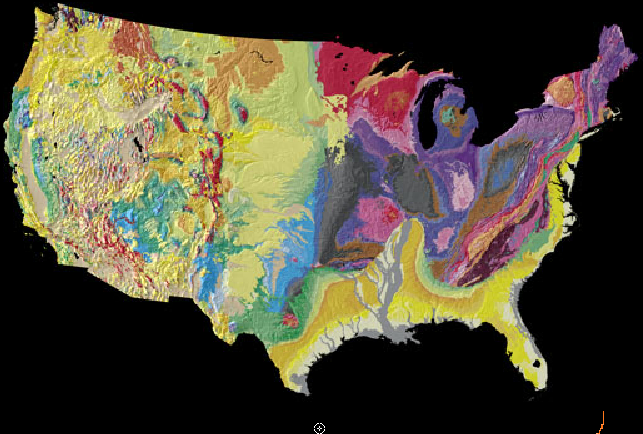
The Geophysical Society of Houston (GSH) is excited to be part of the Maps in Schools project! The goal of the project is to “plant the seeds of geologic curiosity” in students by encouraging an interest in science in general and geology & geophysics in particular. We think that the USGS Tapestry of Time and Terrain (see figure) can do just that and we need your help!
With Earth and Space Science as a fourth year of high school science class in Texas, more students than ever before can be exposed to the geosciences. This is a perfect opportunity for the GSH to share its knowledge and enthusiasm for Earth Science with local students! The USGS map measures 56” wide x 40” tall and offers a great entrée into local classrooms by providing a starting point for discussion.
The Tapestry of Time and Terrain depicts both the topography and geology of the United States. It is the most detailed and accurate portrait of the U.S. land surface and ages of its underlying rock formations yet displayed in the same image. The map resembles traditional 3-D perspective drawings of landscapes with the addition of a fourth dimension, geologic time, which is shown in color. In mutually enhancing the landscape and its underlying temporal structure, this digital tapestry outlines the geologic story of continental collision and break-up, mountain-building, river erosion and deposition, glaciation, volcanism, and other events and processes that have shaped the region.
GSH distributes maps to schools through our various outreach programs, but we also want our members to get involved. We encourage each and every one of you to deliver a map to a school. It could be your kids’ school, your neighborhood school, or the school near your office. Maps are available for pick-up from the GSH office or a meeting with advanced notice. If you need help finding a school or need tips for presenting the map in a classroom or are a teacher who would like a volunteer to present the map to your school, please contact Lisa Buckner at
[email protected].
The Maps in Schools project was initiated by Owen Hopkins of the Corpus Christi Geological Society and is funded by the Gulf Coast Association of Geological Societies (GCAGS), the Houston Geological Society and the Geophysical Society of Houston.